Severe Thunderstorm Watch Issued for All of North Texas Until 9 PM
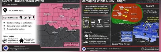
NORTH TEXAS – A Severe Thunderstorm Watch has been issued for the entire North Texas region until 9:00 PM today, as forecasters warn of the potential for large hail, damaging winds, and even isolated tornadoes throughout the afternoon and evening hours.
According to the National Weather Service, scattered severe thunderstorms are expected to develop across the region ahead of a more organized line of storms anticipated to sweep through between 9 PM and 1 AM. These storms could produce hailstones up to golf ball size, wind gusts exceeding 60-70 mph, and brief tornadoes, particularly in isolated cells forming ahead of the main line.
Meteorologists caution that the most volatile window for severe weather will be during the late afternoon into evening, when instability and atmospheric dynamics align to support stronger storm development.
Residents are strongly encouraged to:
- Monitor local news and weather alerts regularly.
- Have a reliable way to receive emergency warnings, such as a NOAA Weather Radio or a mobile weather app.
- Secure any loose outdoor items that could become hazardous in strong winds.
- Review severe weather safety plans and identify a safe place to shelter, particularly in the event of a tornado warning.
Travelers and commuters are advised to remain cautious, as sudden heavy rain, hail, and strong winds could create hazardous road conditions and reduce visibility.
Emergency officials stress that staying weather-aware and taking early precautions can make a significant difference during fast-developing severe weather situations.
Leave a Reply